CarsDataset
Goals
CarsDataset is the CARS internal data structure. The data used within CARS imposes some restrictions that the structure must manage:
can contains array (ex: for images) or list of point (ex: for sparse matches).
can contains georeference, geometry information.
can be used for parallel/distributed computation, i.e tiled data.
can contained overlaps between tiled data;
CarsDataset aims at defining a generic data structure that takes into account this constraints.
Details
Here is an example of one dataset with all needed information.
Attributes
type : CarsDataset can manage Xarray.dataset or pandas.DataFrame
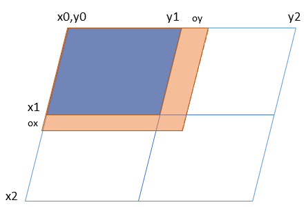
- tilesList of list of Xarray.dataset or pandas.DataFrame. Include overlaps.
example: blue + orange zone on the previous drawing.
- tiling_gridcoordinate position of each tile.
example: for the first tile on the previous drawing: [x0 ,x1,y0,y1]
- overlapscoordinate position of eachtile + overlaps
example: for the first tile on the previous drawing: [x0 ,x1+ox,y0,y1+oy]
attributes : all needed extra information
It is important to note that a tile, if even if you’decided to use Xarray.dataset or pandas.DataFrame could be a delayed or future related to dask definition. See next sections.
Functions
CarsDataset integrates all functions for manipulating the data throughout the framework:
for saving a whole dataset : save_cars_dataset
for loading a dataset written on disk: load_cars_dataset_from_disk
for creating a dataset from another one (same tiling_grid and overlaps) create_empty_copy
for saving dataset tile by tile with futur results, run_save, see next sections.